Satellite technology and ice drift trackers help scientists keep track of seals
Climate change has made monitoring East Greenland seal species more difficult. How can satellite technology help?
Since the 18th century, Harp seals (Phoca groenlandica) and Hooded seals (Cystophora cristata) have been harvested annually for their lustrous fur in the Greenland Sea. The seals would gather annually in staggering numbers on freely floating sea ice floes which were confined to a relatively small geographic location around the island of Jan Mayan due to a unique confluence of currents, one of which is the fast-moving East Greenland current which travels south through the Fram strait close to the Greenland coast, and the other is the East moving Jan Mayen current. This specific phenomenon was referred to as the “west ice” or the Odden ice tongue and was well known to sea farers and hunters in the past.
However, due to climate change, in recent years the ice edge has shifted dramatically to the west resulting in a collapse of the Odden ice tongue feature, the traditional whelping grounds of the Harp and Hooded seal. The last time the Odden ice tongue was observed was in 1998, in Figure 1 satellite imagery is used to show the ice extent and concentration in 1993.

Typical Ice conditions within the Odden (pancake ice of approximately 1 m in diameter, surrounded by frazil) can be seen in the bottom right-hand side. Due to this collapse, the whelping grounds of East Greenland seal species now lay directly in the fast moving, south bound East Greenland current. As a result, their whelping grounds are highly variable from year to year and finding seals for the purposes of commercial exploitation and conservation has become more problematic in the 21st century.
The pups of these drift ice seal species are born and live on the ice for the entire suckling period, which for hooded seals is 4-5 days and for harp seals is 10-12 days. After this period, the pups require ice to haul out on for a period of several weeks while they develop the physiological capability for swimming and diving, before they depart on extended feeding trips throughout the Greenland and Barents Seas.
Estimating the entire seal species population in that area is conducted via counting the number of pups that are produced, and then inferring the number of adults required to produced them. This means that to accurately determine the entire seal population in East Greenland, surveys counting the whelping seals needs to take place within a time window of only a few days.
One of the organizations that is tasked with determining the seal population in East Greenland and advising the Norwegian government on seal pup hunting quotas is the Marine mammals research group, an imbedded part of the Institute of Marine Research (IMR) based in Tromsø. This organization monitors the population size of both Harp and Hooded seals at regular intervals, usually every five years, by accessing their ability to reproduce.
In March 2022 scientists from IMR conducted the most recent survey using the Norwegian research vessel, the Kronprins Haakon (Figure 2), as a base.

This research vessel travelled from Longyearbyen, Svalbard on a course roughly South-West until it encountered the ice edge in the rapidly south moving Greenland current. To locate the position of the whelping ground a helicopter (seen in the yellow circle of the ship in Figure 2) was used as well as planes stationed in both Constable Pynt, Greenland and Akureyri, Iceland. Once the whelping grounds were located ice drift trackers were deployed on the ice floes, to help the scientists keep track of the seals location. These trackers communicated with the spaceborne Iridium satellite constellation once an hour to provide an update of the tracker’s location and thus the current position of the whelping ground. The airborne platforms were then used to capture thousands of photographs which are then are manually examined by specialists who count all seal pups observed. Through this, the timing of the maximum number of newborn seals could be determined and used in statistical models to derive seal population numbers.
Some of the trackers also carried wave motion sensors which showed that some of the seals started their lives on ice floes that experienced significant wave motions. Graphs of significant wave height can be seen in Figure 3.

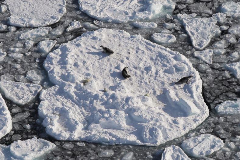
A typical aerial photograph can be seen in Figure 4 showing several Harp seals along with their newly born offspring on an ice floe. In contrast to fully formed Harp seal adults, Harp seal pup fur has a white appearance which can complicate the counting procedure.

In addition to the photographs, for the first time, high resolution optical satellite imagery of seals in their whelping grounds were acquired by scientists from the Royal Netherlands Institute for Sea Research and Wageningen Marine Research. These images, one of which can be seen in Figure 5, and which have pixels of the size 30 ´ 30 cm, and were acquired by the WorldView-3 satellite. This sensor offers the possibility to count individual seal pups, on ice floes using spaceborne satellite technology. While this technology may not render a boots on the ground approach to counting the East Greenland seal pup species populations obsolete, it may help significantly in finding the seals whelping grounds when they do occur, and thus reducing significantly the time spent, distance travelled and thus the cost incurred looking for them. For now though more research is needed.


-
Fiskeri- og havbruksvitenskap - bachelor
Varighet: 3 År -
Fiskeri- og havbruksvitenskap - master
Varighet: 2 År -
Akvamedisin - master
Varighet: 5 År -
Bioteknologi - bachelor
Varighet: 3 År -
Arkeologi - master
Varighet: 2 År -
Musikkteknologi
Varighet: 2 Semestre -
Peace and Conflict Transformation - master
Varighet: 2 År -
Computer Science - master
Varighet: 2 År -
Geosciences - master
Varighet: 2 År -
Biology - master
Varighet: 2 År -
Technology and Safety in the High North - master
Varighet: 2 År -
Physics - master
Varighet: 2 År -
Mathematical Sciences - master
Varighet: 2 År -
Biomedicine - master
Varighet: 2 År -
Molecular Sciences - master
Varighet: 2 År -
Law of the Sea - master
Varighet: 3 Semestre -
Biologi - bachelor
Varighet: 3 År -
Medisin profesjonsstudium
Varighet: 6 År -
Nordisk - årsstudium
Varighet: 1 År -
Historie - årsstudium
Varighet: 1 År -
Engelsk - årsstudium
Varighet: 1 År -
Luftfartsfag - bachelor
Varighet: 3 År -
Arkeologi - bachelor
Varighet: 3 År -
Religionsvitenskap - bachelor
Varighet: 3 År -
Informatikk, datamaskinsystemer - bachelor
Varighet: 3 År -
Informatikk, sivilingeniør - master
Varighet: 5 År -
Allmenn litteraturvitenskap - årsstudium
Varighet: 1 År -
Likestilling og kjønn - årsstudium
Varighet: 1 År -
Historie - bachelor
Varighet: 3 År -
Religionsvitenskap - master
Varighet: 2 År -
Geologi - bachelor
Varighet: 3 År -
Biomedisin - bachelor
Varighet: 3 År -
Kjemi - bachelor
Varighet: 3 År -
Samfunnssikkerhet og miljø - bachelor
Varighet: 3 År -
Matematikk - årsstudium
Varighet: 1 År -
Ergoterapi - bachelor
Varighet: 3 År -
Fysioterapi - bachelor
Varighet: 3 År -
Radiografi - bachelor
Varighet: 3 År -
Russlandsstudier - bachelor
Varighet: 3 År -
Automasjon, ingeniør - bachelor (ordinær, y-vei)
Varighet: 3 År -
Samfunnssikkerhet - master
Varighet: 2 År -
Kunst - bachelor
Varighet: 3 År -
Kunsthistorie - master
Varighet: 2 År -
Farmasi - bachelor
Varighet: 3 År -
Farmasi - master
Varighet: 2 År -
Religionsvitenskap - årsstudium
Varighet: 1 År -
Romfysikk, sivilingeniør - master
Varighet: 5 År -
Klima og miljøovervåkning, sivilingeniør - master
Varighet: 5 År -
Sosialantropologi - bachelor
Varighet: 3 År -
Bærekraftig teknologi, ingeniør - bachelor
Varighet: 3 År