AKMA 1 - Expedition 2021
By Valentina Lanci
The AKMA 2021 Expedition took place on the Norwegian Research Vessel Kronprins Haakon, in May and June 2021. Prior the cruise, there was a two day crash-course which covered the main topics of the AKMA project. The course was organized at UNIS in Longyearbyen, and the goal was to inform the participants of the main expedition objectives and the AKMA project.
During the expedition, students and scientists engaged in activities and experiments at sea. The activities focused on understanding how methane is produced, consumed and utilized by organisms and how it affects the seafloor. As science communication is an increasingly valued skill for an Early Career Researcher, the students onboard wrote blog posts or made videos for outreach. We also created short-form content on Instagram, during and after the expedition.
If you are interested to know more about this expedition, read the cruise report HERE.
A video by Christine Lockwood-Ireland - August 25, 2021
A video by Maximillian Weber - August 10, 2021
A blog By Marie Stetzler - July 13, 2021
It’s the little things that give away that we’re in Longyearbyen, Svalbard. Like having to leave your shoes in a locker at the entrance of university and run around in socks in order not to drag any mud in (if you come as unprepared as us visiting scientists – the locals have their slippers ready). Or the snow scooters and chunky chain vehicles cruising outside. Or the daily reminders that you share land with polar bears: the “no riffles”-sign at the entrance of the post-office, and every hotel lobby displaying “polar bear emergency” flyers. Better being cautious than sorry. The ultimate give-away though might be the drizzling snow fall despite it being end of May!
.jpg)
Longyearbyen is our harbor of departure. Our vessel, the Kronprins Haakon, lies on a dock not far outside of the city. Before we can set sail though, all the equipment has to get onboard and be set up. While a crane heaves boxes and gravity core liners from quay onto deck, we have courses at the University Center Svalbard (UNIS). As PhD students, we get updated on the state of the art in microbiology, geochemistry and oceanography of our study area, which stretches from the island Prins Karls Foreland west of Svalbard to the Svyatogor ridge, in the midst of the Fram Strait. We all come from a diverse range of fields, so this ensures everyone is on the same page and gives a solid overview of our colleague’s domains of expertise. This science-briefing will prove useful already a couple of days later.
On the 23rd (of May), it is finally time to leave to our first station, offshore Prins Karls Foreland. Satellite radar imagery revealed an unexpected feature in this area: a dark, persistent spill, contrasting with the clear hues of the surrounding ocean. This dark color appears when the reflection of the radar signal from the water surface back to the satellite sensor is dampened by the presence of… oil! Nothing to be concerned about though, natural oil leakage from deep sediment sources is not uncommon. Once on site on the morning of the 24th, everyone is staring from the windows of the bridge down to the sea surface, where dark, rainbow-shimmering circles spread. We witness tantalizing oil bubbles from 90m deep reach the surface.

When looking at the live stream from the ROV, our robot eyes under the sea, the slow flow of oil from the seafloor contrasts sharply with the larger spills at the surface. Here, bubbles looking like tiny black marbles slowly detach from the seabed, rising through the water column sluggishly due to the viscous drag. While rising, the fraction of methane gas they contain expands, making the bubbling at the surface look more extensive.
.png)
Since gaseous exchanges between bubble and water column determine how much gas is released throughout the water and up to the atmosphere, oil bubbles might rise slower but transport more gas (such as methane) to the surface than purely gas bubbles. It is hence important to look at the presence or absence of bubbles present at a given seepage area. Also, it gives us information about the processes potentially creating the gas, as we were reminded in one of the earlier courses.
With this in-situ lesson of bubbleology, the cruise is off to a good start!
A Blog by Andreas Hagset - July 13, 2021
As a geologist, I was excited to join the AKMA expedition for its second leg, crossing the Barents Sea from North to South. We set out from Longyearbyen, Svalbard, on the 30th May with the Research Vessel Kronprins Haakon and started preparing for ROV operations and sampling the seafloor.
One of our first objectives was to investigate an active oil seep from west of Svalbard. The oil had created a slick on the sea surface, making it possible to identify the area using images from satellites. When we arrived at the seep site, the smell of hydrocarbons hit us immediately. Looking over the edge of the ship, we could see oil ‘bubbles’ bursting at the surface and coating the water in rainbow colours.

In the following hours, we deployed the ROV Ægir 6000 and when Ægir reached the seafloor we started to investigate aiming to locate where the oil was leaking and sample the seafloor there.
At a depth of approximately 100 m below the surface the ROV found a white spot on the seafloor. This white spot was actually a colony of bacteria that live in association with hydrocarbon seeps. We therefore knew that this location would be quite interesting. When the ROV moved closer and the camera zoomed in, it revealed oil bubbles leaving the seafloor and migrating up into the water column towards the surface where they eventually burst.

From a geologists perspective, this is very exciting as the presence of oil indicates that there are rocks somewhere close which we call source rock. Source rocks were once upon a time deposited in areas like estuaries, where a lot of plant matter (leaves, for example) are buried along with the sediment, and when they eventually get buried the plant matter can turn into oil and gas.
We couldn’t stay long at this site, so we headed towards other locations in the Barents Sea. Many other features and phenomena need further sampling and investigation. On board the Research Vessel Kronprins Haakon, scientists work around the clock in order to sample and investigate as much as possible. The data collected on board will give valuable insight to past and present marine environments. It has been such a unique experience to see these systems with our own eyes, and to try understand the relationship between the organisms feeding on methane and subsurface geology.
A Blog by Julian Janocha - July 13, 2021
The last stop of the AKMA expedition was a visit to the Norwegian-Svalbard continental slope. Here, at a depth of 1250 m below sea level, we find an active mud volcano. Håkon Mosby Mud Volcano was discovered in the 1990’s and has been studied since.

After arriving at the mud volcano around 9 am, we immediately got the ROV Ægir 6000 ready for deployment. All the scientists aboard were stoked to see an offshore mud volcano with our own eyes - well, not directly with our own eyes but the live feed from the ROV is as close as possible to with our own eyes. Now the wait starts, it takes 45 minutes for Ægir to reach the seafloor. As to be expected from a mud volcano, we found plenty of mud but we also were greeted by vast bacterial mats, sting rays, large colonies of tube worms, fishes and many other living organisms. But of course, we are not just interested in the creatures that we can see, we are also interested in the sediments and potential microorganisms living in the sediment. Therefore, we started taking samples of the seafloor and the sediments buried immediately below the seafloor for further analysis. During the ROV dives, we were extremely lucky to observe an active eruption of the mud volcano. After the ROV returned to the surface we began larger scale sampling using a box and a gravity core.


A blog by Cornelia Binde - June 23, 2021
Similar to taking your temperature during a fever, we can measure the temperature of the Earth, at least the shallow part. Temperature measurements on this scale are usually carried out using a giant steel thermometer, known as a heat flow probe. The heat flow probe used during the AKMA expedition weighs over 1000 kg, and has 22 temperature sensors to measure the upper 6 meters of seafloor sediment.
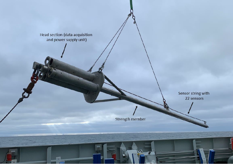
The probe is lowered down into the sediments and usually records the temperature for about 30 minutes. After 15 minutes of sitting in the sediment, the probe can generate a pulse of heat - the decrease in temperature after the heat pulse can tell us about the sediments’ ability to transfer heat. After sitting in the sediment for half an hour or so, the probe is brought back on deck and all the data can be retrieved and processed.
So, why do we measure the temperature of the Earth? Firstly, temperature is an important parameter controlling the formation and stability of gas hydrate - which are solid compounds of frozen methane and water. Changes in temperature conditions can melt the hydrates and release methane gas into the ocean and atmosphere. Temperature measurements are important for understanding and modelling hydrate stability. Temperature anomalies may indicate the presence of gas, or gas migration as well. Methane affects biological, chemical and geological processes in the ocean so it is very important to understand why and how gas is released from the seafloor.

A blog by Griselda Ortiz - June 21, 2021
What pops into your mind when you think of the seafloor? What about the seafloor at 2000 m depth in cold Arctic waters? Maybe not clear blue waters and sunshine illuminating a colorful coral reef with some fish, but the Arctic seafloor is just as interesting and beautiful. On the seafloor we can find an amazing community of organisms, called benthic, living off everything that falls from the water column.
During our trip, we were lucky enough to have a robot equipped with cameras (called an ROV) to see what’s happening on the seabed. This robot is able to bring tools to take, for example, a rock or a tube filled with sediments (a core) back to the ship so we can study them. With its cameras we have been able to see organisms and communities such as colonies of bacteria, fishes, tube worms and sea anemones.
But even when we only see sand, it doesn’t mean there is no life. On and in the seabed a group of tiny organisms called foraminifera find their home. These unicellular organisms are usually smaller than one millimeter and can live both in the seabed (benthic) or floating in the water (planktic). They usually have a shell made of calcium carbonate, similar to snails, which make them really sensitive to changes in the environment. These organisms are extensively studied not only when they are alive in the surface sediment, but when they are buried in the deeper part of the sediments as fossils after they die. Foraminifera are often used to determine how old the sediment is. Imagine, for instance, a three meter core going through the seabed. If we cut it every centimeter, by analyzing the shells of these organisms we can find out how “old” the sediment is, in a similar way to aging a tree by counting its rings. When foraminifera die, their shells record information about the environment they lived in. Thus, they can give us information about the temperature or the pH of the water when they were alive.
.png)
.png)
A blog by Carmen Braun - June 6, 2021
As a marine geologist studying glacial and interglacial sediments, I am much more familiar with the sediments below the seafloor than the organisms that may live on or within the seafloor. In biology terms, those are all considered benthic organisms, and those on the seafloor are epifauna, while those living at least partially within the seafloor are infauna. Since one of the main tasks on board is logging what we see from the cameras on the ROV, I have had to learn how to identify some of these living things! In this guide, I will present to you some of the cool organisms I have seen while logging, and fun facts to go along with them.
.jpg)
Very bright patches
These white and sometimes blueish patches stand out very well compared to the rest of the grey and brown seafloor, and are actually microbial mats, areas where microbes from the genus Beggiatoa colonise the seafloor in areas with methane seepage.
Claudio Argentino, a postdoc from UiT, provided the following fun fact: while very obvious in images from the seafloor, they are very hard to see at the top of cores.
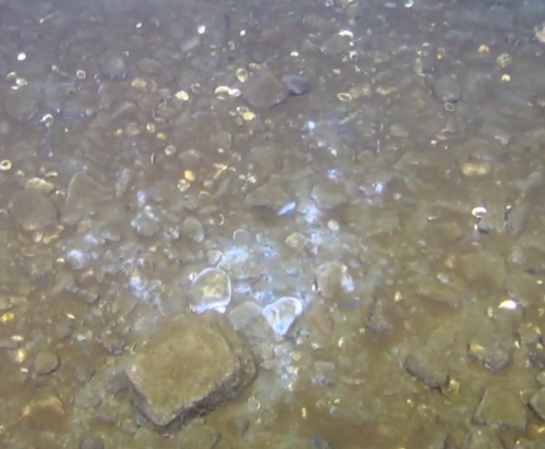
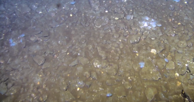
Tiny grey spots
At first, I thought these little grey things might be very small microbial mats, but I am not a biologist, and was wrong. Indeed, what we see are the filter parts of Polychaetes, they are commonly called “tube worms”, and are worm like organisms that live in tubes, which generally extend below the seafloor. These tubes are not new to me, even as a geologist, since the tubes and their burrows leave traces in the sediments I study. Fun fact: As the ROV passes over them, the slight disturbance often prompts them to close up very suddenly. I imagine they do this with a quick, quiet “shlop”…
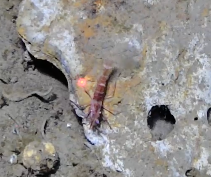
Shrimpies!
We have seen lots of shrimp (pictured) and krill, both of the phylum Arthropoda. These were already familiar to me, even though I’m not a biologist, since shrimp are human food, and krill are whale food but I was not sure how they differ from each other… Luckily, I was able to ask Camille Saint-André, a technician with the Institute of Marine Research, about this: krill are smaller than shrimp, have gills, and can live for about a decade, while shrimp do not have gills, and live for only one or two years.
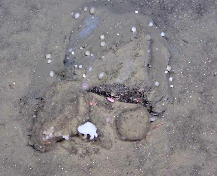
Round Blobby Things
These round things are, in fact, sponges (phylum Porifera)! Of course they are not the kind I use to clean my dishes or the tools I use to study my sediments, but rather filter feeding animals.
This fun fact is from Sofia Ramalho, from the University of Aveiro: Sponges can be really squat and round like those in the photo or really long and skinny like sticks, and some grow like a crust over a surface.
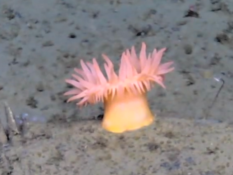
Anemones
Easy to spot, difficult to pronounce, even this geologist can recognise anemones (Order Actiniaria). I used to associate these with warmer waters, but these predators can also live in rugged environments, like the Arctic.
Fun fact: they are part of the group Cnidaria, along with jellyfish and corals.
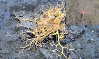
Lost tumbleweed
This tangled mess of bright yellow-orange branches is a very cool brittle star, or Ophiuroid, more specifically a basket star. Not all brittle stars have quite so much arm-action going on, the little pinkish one in the inset photo is less chaotic with only five, non-branching arms. Fun fact: there are 2064 different brittle star species that we know of, but only 73 of these have been observed in the Arctic (from doi:10.1371/journal.pone. 0031940).
Wait, was that a squid?!
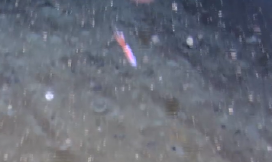
Yes.
Fun fact: There is only one species of squid that lives permanently in the Arctic, Gonatus fabricii (Ecological role of the Arctic’s most abundant cephalopod, Gonatus fabricii - Framsenteret).
Scientists who want to study the interior of the earth face many obstacles. The most obvious obstacle is the one responsible for life on Earth – oceans cover more than two thirds of the planet. For seismologists, who use earthquakes (but not only!) to study composition of the crust, the mantle and the core of the planet, it is important to have a network of instruments spread out across the earth. But how do you ensure good coverage when it is impossible to simply drive into the field and deploy the device?
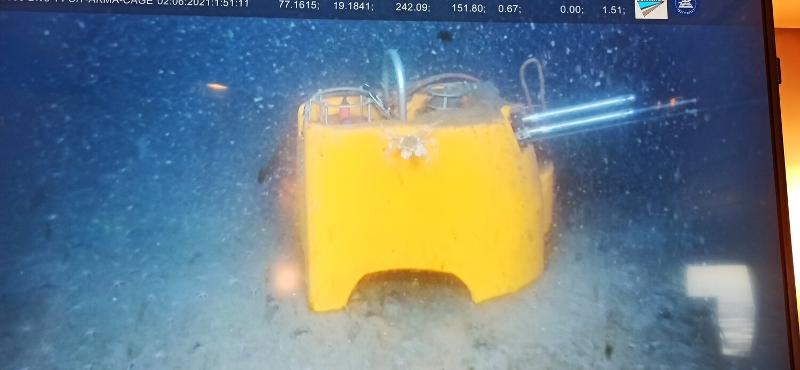
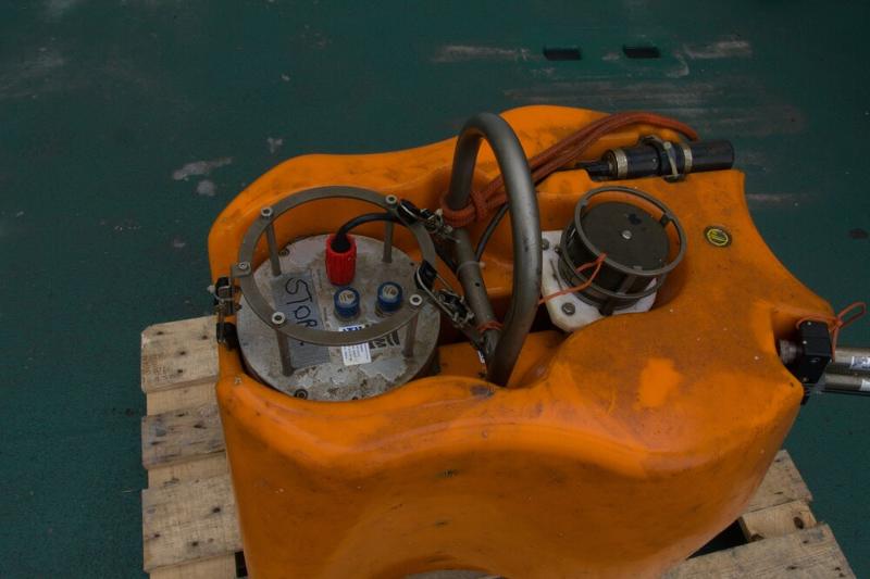
Having an instrument permanently on the sea floor is very expensive: you need something that can survive harsh salt water and incredible pressures, and you need to have it connected with a cable to land, which is simply not feasible far off shore. The middle step, which is a bit cheaper, is to deploy ocean bottom seismometers (OBS in short). OBS is an all-in-one seismological package: it has seismometer to record earthquakes, hydrophone to record waves travelling in the water, batteries to last up to a year, and a recording unit. It is buoyant (which means it floats in the water), so to keep it on the ocean floor you add some extra weight at the bottom. When you come back with the ship after some months, you sent a radio signal and a tiny mechanism that keeps the entire unit attached to the weight should rotate, free it from the iron grip of the weight and let it come back smoothly to the surface. That’s the theory, at least.
Because that exactly what University of Bergen did in summer 2020. They sent command to release. And waited, waited, waited… and nothing! The instrument was lost. But why, what happened? Was it stuck in the mud, did something fail to work, has it been eaten by a polar bear?
No way to be sure.
Until the AKMA expedition in 2021, that is! One of the goals was to go back to the location of the OBS drop, use a super fancy remotely operated vehicle (ROV), and look for it. This is exactly what we did. It didn’t look promising at the start. While the area was relatively shallow (a mere 150 m of water depth), there was a lot of “stuff” floating in the water and every move of the ROV caused big plume of sediments to rise, visibility was awful! I was pretty worried for a good 15 minutes.
And there it was! Sitting nicely on the seafloor, serving as a new home to a very lonely crab, not even covered by much sediment. From there it was easy to determine that the releaser failed to work. The tiny thing holding entire instrument for dear life to the weight at the seafloor hadn’t rotated when it was commanded to do so. With the ROV’s strong mechanical arms, we lifted the entire thing up, put it in the basket lowered to the seafloor, and lifted back to the surface. Scientists in Bergen can breath a sigh of relief now! A whole year of experiment has not gone to waste.
